Tuesday, May 12, 2015

May 8th Needle in a Haystack Tornado!

May 8th, 2015 would be my third chase trip of the year and my second plains run of the storm season. The week would start out like any other, as the GFS computer model began to come to life, showing a deep digging trough in the southern plains. My work schedule came out for the week and I should have known it was to good to be true. Magically, I had gotten that Saturday, Sunday, and Monday off of work.

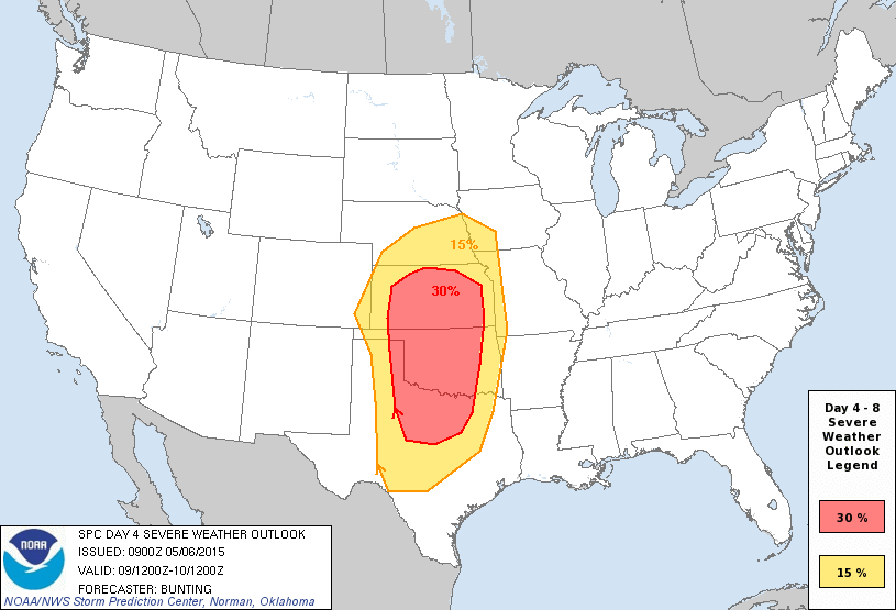
About 5 days out the SPC highlighted a risk area from Texas, up into Kansas with mentioning of the magical "T" word storm chasers love to hear. The following day the SPC highlighted a 30% area from again, Oklahoma, Texas, and Kansas as it was becoming more clear Saturday could be a potentially big day. However, some veer back veer issues were preventing me from getting to terrible excited. That is, until the NAM did what the NAM does and was forecasting a high end tornado outbreak from Southwest, Oklahoma up into Kansas. With some of the signs even being compared to April 14th, 2012. Regardless, Saturday was looking like the most significant chase day since April 14th, 2012.


Just days before I messaged my good friend Brennan Jontz about teaming up for this chase. During that time we had planned to chase Saturday and drive North for Sunday along the triple point. Well, the NAM was trying to make Friday look like an absolute classic "Day before the day" setup. Meaning a small scare tornado outbreak, followed by "The" tornado outbreak. So, we both cleared our schedules and headed out to the great plains that Thursday evening.

My trip got off to a rocky start. After driving through the night after leaving my shift at work. I was becoming so tired I was seeing things, and with Norman only 1 hour 30 minutes away I didn't feel like sleeping in my car. I sped up because I was so ready to sleep at this point I didn't care. I set my cruise for 10mph over and sure enough. I see red and blues in my mirror as I hop on 35 in OKC. Yea, I made it clear to OKC before it happened. Got a ticket for doing 85-75, but the cop was nice about it so its whatever. Live and learn.


This system was 3/3 on tornado days, and me being stuck at work and now having much more parameters to work with I was very excited. That is, until the new outlook came out talking about how morning convection was possibly going to ruin the day. Looking over briefly at modes when I arrived in Norman before heading to bed. It sure seemed like a real possibility.

None the less, the chase was still on! 9am rolled around and I hopped in Brennan's car and made our way towards Wichita Falls, Texas. We made it to Lawton when a severe storm was trolling us just off to the west by about 40 miles. It wasn't out of the way and we could simply drop back South into Texas. So we made our way to just South of Roosevelt, Oklahoma before realizing this storm was junk and leave it. While on our way South, I noticed an area of some enhanced helicity over top Vernon, Texas (about 40 miles or so West of Wichita Falls) and we decided to adjust our target to Vernon. It wasn't long after we arrived at McDonalds for our storm to initiate and for the chase to be on.

On our approach the storm was getting its act together fast, with a very well defined hook on radar and already severe warned with rotation showing up on radar. We blasted West towards Quanah and on our way the first tornado warning came out. It was also becoming clear, that yet again, we would be chasing another HP (High Precipitation) storm, making it hard to see tornadoes. We chased this storm very aggressively and it would eventually pay off big time. But we'll come back to that.

After battling a one lane construction road we cleared the precip and got our first view of the base of the storm. At first glance you'd swear a huge wedge was on the ground. But it was actually the meso scraping off of the hill side. Can you say low LCL heights? We parked off the road briefly, and although there was some rapid rain bands a tornado did not appear imminent anytime soon. Texas has a very limit road network, and the side roads were nothing but mud. So we went back North into town and were in the core clear back until almost we entered Vernon again. The whole time there were insane inflow winds feeding into the storm, and the low level clouds were screaming into the meso. Go figure, we clear the core to get back into position and a confirmed tornado report comes in. Thankfully, it was brief and not photogenic.


We chased this storm for another good hour or two with nothing to show besides a massive inflow tail that was basically scraping off of the earth and the brightest green glow I have ever seen. We did notice a small area of rotation to the North. So, we took highway 183 and positioned ourselves just East of the couplet. Well, that couplet quickly faded away. We continued East on Farm to Market 370 before pulling off again for another look. Frustrated, we both agreed the only way we were seeing a tornado today was by getting right up in the bears cage.

It didn't take long to see the area of interest. Rain bands began to dance, and twirl. Clouds began to move and it was go time. We quickly blasted East towards this area only to have it kind of slow down and rotation be almost gone. Discouraged, I looked down at radar, and to quickly check Facebook and to find roads home. When I look up and see a huge wall cloud, followed by rapid rotation and then.....you guessed it! Tornado! Not just a spin up either, a large multi vortex that began to wedge out!

We filmed the tornado as it grew in size for about 3-5 minutes before it became rain wrapped. Then I looked over and saw rain bands moving faster than I have ever seen rain move. It looked like a freight train was flying past! I'd estimate winds easily over 100mph. Power lines beside us began to bend and lean over as we scurried South. Then, out of no where boom! A tree branch clips the front of the car and flies into the field beside us. The RFD we were in was absolutely awesome. Once it passed, we went back to check on damage, only to find the stop sign we were parked beside was bent forward and down from how strong the RFD winds were.

What could have made this day any better? We were the only chasers who saw it! Which as everyone knows is a very rare occurrence in this day and age. Brennan and I did everything right this chase day and could not have been any happier. That is, until nature wasn't done showing off! On our way home she put on this stunning mammatus/sunset combo display near Lawton, Oklahoma!


Brennan celebrates the end of an awesome chase day, with a very frustrating, but well played chase day ahead!


Sunday, April 12, 2015

April 9th Clinton, Iowa EF1 Tornado Close Range!

April 9th would be a very tough, but rewarding chase. But unfortunately we didn't come out with the top prize. But second place isn't too bad! But, we'll get back to that. I had dinner with my friends Brennan Jonz, Daniel Auel, and David Baxter III in Wichita after busting the day before by choosing the wrong storm and going against my original forecast. We decided to convoy up to Iowa, where another chase day (potentially bigger) was setting up. I was solo this trip and convoying would help keep all of us awake. We all decided to sleep for a few hours in Cameron, Missouri before heading to Southeast Iowa. We woke up at 730am, and got donuts at the local shell station where I bumped into my friend Bill Oosterbaun. We were very confused the night before as to why the SPC outlook had the tornado potential so far East, after the trough had clearly slowed down, initiating storms 40 miles further West the day before than originally forecast. By 13z (8am CDT) the SPC bumped back the 5% tornado outlook to include our target area, and by 1630z (11:30am CDT) the SPC issued a 10% enhanced risk for tornado probabilities for extreme Eastern Iowa and North Central Illinois.


I had been liking the triple point play in Southeast, Iowa for better backing of winds, as veered wind shear was a major issue this day. Looking at Mesoanalysis that morning, I was really starting to like Southeast Iowa. Not only that, it was cloudy at the original target of Davenport, Iowa and the Warm Front hadn't even lifted North of I-80 yet. I sent Brennan a text (who was in the vehicle ahead of me) that I think we should head towards Ottumwa. We all mutually agreed and once arriving, adjusted our target a little more towards Washington, Iowa. I was very paranoid about the river crossing, and if storms produced tornadoes I did not want to get screwed over by not being able to cross the river. While driving towards Washington, I noticed skies beginning to clear and moisture surging North. After seeing rainy skies (not good to see on a chase day) and seeing this made me excited After eating at a local diner/gas station combo in Ainsworth a mesoscale discussion was issued for storms initiating along the Cold Front near the Missouri/Iowa border and a Tornado Watch was issued shortly after.


We boggled a little West and decided to let the storms come to us since they were moving into a better environment. While watching, and waiting to see if storms would ever become isolated and have a storm become dominant I was calling a bust. Storms took on a more linear mode for quite some time and it didn't appear that a single storm would take over anytime soon. We continued following the storms East through the town of Washington when a tornado warning was issued. If there was a tornado, it was heavily rain wrapped and likely weak, as the storms were still a linear bowing segment.


Frustration began to take over, and I briefly considered dropping South towards I more isolated storm. But I knew this was the only game in town for tornadoes since it was riding the Triple Point. As we neared Davenport on the SW side and shortly after I texted Brennan to take I-280 North around Davenport because I didn't want to give up and neither did he. I noticed something though, the new Severe Thunderstorm Warning box was issued more to the East instead of to the Northeast. The storm appeared to be taking a right turn. Then, a tornado warning was issued. I briefly got excited, but remembered how the earlier tornado warning went, so I looked at the velocities and it revealed an ominous sign. A very strong couplet was showing up on radar, with a TVS (tornado vortex signature.) I quickly called Brennan and told him we needed to floor it and go. I was afraid we weren't going to catch it, as construction and 55mph speed limit plagued us. Finally the road open and we unloaded and quickly got on 80. There was no other good North options so we had only one shot at seeing this tornado and into the bears cage we went. I pulled ahead of Brennan as again my frustration was taking over with traffic and possibly ending the day as a bust as we blasted North on highway 61 where I received a call from Brennan that he had to get gas and was running low. I checked my as gauge and I was still good so we parted ways and I took off further into the bears cage. I also lost David some where in the mix. I was also getting mad because a strong couplet was still present directly in front of me and I should have been seeing a tornado by now.


I rounded a curve and blasted East on highway 30. I heard someone honk at me, confused I looked over and I had just past my good friends Adam Lucio and Alec Scholten. We both played tag on this road and again, a strong velocity couplet was present, we were in the perfect spot BUT WHERE IS THE TORNADO?!?! We continued East and I saw an ominous lowering just off to my South. Got a few miles up the road and the "its happening" moment settled in. The clouds began to spin, the rain curtains danced, and the inflow jet was at our backs as we both creeped to a stop. Vorticies started dancing in the road just 100 yards in front of us. I continued closer and got within about 75 yards of the multi vortex tornado as it crossed highway 30. The tornado then fully condensed and grew in size before coming fully rain wrapped.


I slowed down quite a bit due to blinding rain and not wanting to rear end a possible panicked motorist parked along side the highway. Power went out in the town of Clinton, and I began to worry about the town as the tornado was taking aim. Thankfully this tornado was not a strong one, but it did demolish a barn and did damage in several other locations, earning it an EF1 rating on the Enhanced Fujita Scale. I caught back up to Alec and Adam and we jumped for joy in a shell parking lot after seeing the first and what we thought was the only decent tornado of the day, and at close range!

I am still in debt to Alec for this video grab of me driving by the tornado!


Well, our mood quickly changed, as a storm fired off some sort of boundary in Illinois and produced a large track, very photogenic, and violent tornado near Rochelle. So again, I got stuck with a consolation prize just like November 17th, 2013. But, I wasn't too terribly mad because a lot of chasers didn't see anything that day, and this was my first solo tornado! This was my second tornado of the year, and i'm already off to a better start than 2014. So I can't wait to get back out there and hopefully be on THE tornado of the day!

Footage from the day..

Short Clip
https://www.youtube.com/watch?v=tT-V_OIko-o

Full Clip
https://www.youtube.com/watch?v=6i_Df2aKhcA


Sunday, March 29, 2015

First Tornado of 2015! 3/25/2015

After a record low start to the tornado season yet again for the fourth year in a row, mother nature finally awoke from her slumber. I had originally planned this trip as a photography/business trip with my new chase partners Stephen Jones and Cody Howard for the 2015 season. While out in New Mexico models were hinting at a short wave trough digging into the southern plains on Wednesday (March 25th). A day 4 outlook was highlighted by the brilliant minds of the Storm Prediction Center in Norman, Oklahoma. A place I will call home in October. Wednesday finally came after exploring the many sites in New Mexico, and this would be one of the most complicated forecast I have ever done.

Target 1 was the dryline/triple point centered over the OKC metro. Target number 2 was the Warm Front draped across Northeast, Oklahoma and Southwest Missouri, and target number 3 which was just the dryline.


All targets had their pros and cons. A main concern this day was a Cold Front that was forecast to surge South, under cutting storm development before they would have a chance to produce tornadoes. Mesoanalysis was carefully monitored that day to see where the Cold Front was located and how fast it was moving South.

Target 2 was my favored location the day before, due to enlarged hodographs. The problem with that target is it would be much closer to the Cold Front and if storms did go up we feared they'd be undercut and not be able to do much. Hodographs mean nothing if the storms get undercut by cold air and die. Target 1 which ended up being our target offered more backing with winds, higher instability, and further away from the Cold Front when it decided to come crashing South. This would offer storms a longer time to take advantage of the parameters in place, and have a better shot at producing tornadoes before being undercut. The third and final target was the dryline itself in Southern Oklahoma along the river. However, with a large and almost unbreakable cap in place we feared storms would not go up down there at all. But, if it did go, those storms would be well ahead of the Cold Front and would likely produce tornadoes since it was in a similar environment as our target.

Later that day the forecast would prove to be harder than originally thought. At around 2-3pm a gravity wave pushed through clouding up skies and even bringing mammatus over the metro area (our target). I personally was not fearful that it would ruin the environment, I remained optimistic as I thought the cloud cover would help bring down temperatures and prevent higher temp/dew spreads which were already pushing 15-20 degrees. Anything above that is not good at all for tornadoes, let alone storms in general because they would be very, very, elevated. Then, as we were approaching our target of El Reno, Oklahoma. I clicked on radar, only to see a blimp showing up on radar. Completely out of the forecast area, and about 3 hours sooner than any model was predicting. Confused, with no way to catch it due to traffic accidents on I-40 we rushed up to Edmond, Oklahoma where we would sit and hope for later development.

As we waited wonder when, or if the cap would ever erode before the cold front arrived, we watched helplessly as the storms up Northeast quickly went severe warned. For the longest time we were not worried because the storms appeared to be multi cellular and elevated. It was not pushing 5pm and we still had no decent tower in site. We looked up calling a bust as cirrus still plagued the skies above us. We also noticed an ominous feature on radar. Crashy the Cold Front was now in El Reno!! This is when I started sending out the "bust party in Norman" invites. But, mama nature had something else up her sleeve. Not 15 minutes later a tower exploded in front of us, and bust through the cap that was in place. I was jumping for joy as if I had just witnessed a huge tornado. But wait? A storm forming behind a Cold Front? How? I'm still not really sure. My guess is it was a very shallow front and the temperature gradient wasn't substantial. With that being said, this was still unusual. There were multiple storms that blew up all around us that all showed supercell characteristics.


This guy blew up almost right over our heads as two storms exploded over by El Reno. See that line in front of the storm? That's the front. That the storm is behind. Again, not really sure how or why that happened. Visually, the storm looked like garbage. It was elevated, and there was cold air spitting out from it. But, what if we left this storm? It was very isolated and away from the other storms nearby. We made the decision to leave it and continue towards El Reno, where those storms were taking on supercell characteristics. After battling construction traffic and seeing the skies turn into darkness by the approaching storms we hopped onto the I44 turnpike and quickly made our way around the metro to hop on I-40 and shoot West towards the approaching supercell. The storm was visually HP but was getting an ominous hook echo feature. Again, not really sure how because its behind the front at this point.


We are now about to be faced with "The Bears Cage". This is an area where if there is a rain wrapped tornado you are going to have a better chance at seeing it. This is also one of the most dangerous spots to be in while storm chasing. But, limited roads and city traffic forced us to chance it. We continued West on I-40. Skies began to turn black, and a lower emerged into view. Lightning illuminated a very visible funnel cloud (which was also documented with damage by storm chaser Val Caster). Shortly after this we witnessed multiple power flashes. A tornado was now on the ground. Again, some how a tornado touched down while behind the cold front. I looked back just as the core was about to overtake us and as we were about to take an exit to turn around and follow the area of interest. Right before rain swooped in I saw multiple vorticies dancing around about 3-4 miles to our almost SouthEast. I'm still not sure if this was a separate tornado, the beginning of the Moore EF1 tornado, or the same tornado we saw earlier. So, I still count it as only 1 tornado documented that day.

This velocity image provided by Jesse Post shows my location (in the white circle) as we saw the funnel cloud illuminated by lightning. Clearly a couplet going on there.

Above is a video grab of the tornado as it begins to briefly touch down. Shortly after we turned around we witness a large amounts of power flashes. Again, unsure if they were caused by the same tornado, or other spinups. Power flashes began to our South, continued directly in front of us to the East, and then more followed to our North, following a velocity couplet on radar. At this point, Alex has already reported a tornado on the ground with power flashes observed. No tornado warning goes out due to these storms being behind the front, and it being hard to believe there are actually tornadoes occurring.


This video grab you'd think was taken a long time later. This was actually only taken about 10 minutes later from the video grab of the tornado. This storm was so dark, it turned day into night. I will note it is only 6:30pm at this point and the sun had only began to set. 45 seconds after this power flash, multiple power flashes occurred beside us in/near the town of Yukon. Winds are roaring in this direction and rain bands are wrapping around.


Power flashes finally come to a stop, and it was time for us to find shelter and ride out the core as we entered the OKC metro area. At this point sirens are sounding (however no tornado warning was issued) this was prompted by the local area.. Which was a good call considering what had just happened. We parked near a car wash and documented golf ball-hen egg size hail and probably some tennis balls mixed in there some where. The core past and we hear on the radio "tornado on the ground in Moore". Our heart sinks and we immediately jump into the car and blast South. An area ravaged by strong tornadoes, and the SAME areas hit by the 2013 EF5 tornado were being hit AGAIN! Not only that, this tornado was moving Southeast in the general direction of Norman, where my car was parked and the homes of my best friends. From what we were visually seeing, and from reports the tornado damage looked no higher than low end EF2. This was later given an officially rating of a strong EF1 tornado.

Lots of controversy still remains about the amount of time it took the NWS in Norman to issue a tornado warning for that storm. But, i'll keep my opinions about that quite. I have not heard any confirmation on our tornado, nor will I ever most likely. Especially given the events that happened in Moore. The damage Val Caster documented looked like EF0 damage thankfully. My personal opinion is there was likely a couple spin ups. But I only count the one I visually saw. 

Conclusion: It still stings that missed the very visible, and pretty photogenic Sand Springs EF2 tornado (located near Tulsa) which had been a target we were talking about the day prior. But after battling tough decisions, and a tough chase day in general we still came out with big hail, a tornado, and got the rust off the equipment! This was also my first March tornado!